To celebrate the Glen Park Association Website turning ten years old, we are reposting some of our favorite stories from the last ten years.
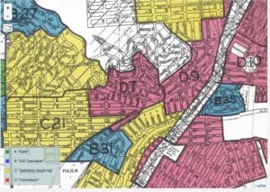
 During the 1930s, a New Deal agency called the Home Owners Loan Corporation asked mortgage lenders, developers and real estate appraisers to draw up maps assessing the risk of lending money to a person buying a home in certain cities. The maps were color-coded, and neighborhoods colored red were considered very risky for loans.
“Mapping Inequality” is a digital effort to show how redlining helped create the massive racial inequality of wealth in the United States. From the website’s introduction:
“Across the middle third of the twentieth century, arguably the most prosperous decades in American history, [New Deal] agencies worked with public and private sector partners to create millions of jobs and help millions of Americans buy or keep their homes. At the very same time, federal housing programs helped codify and expand practices of racial and class segregation.”
Click on the neighborhoods (D7 and D9 equal Glen Park on the map) to read what the Home Owners Loan Corporation had to say about our neighborhood. Learn more about how neighborhoods were assessed here.