The intersection of Diamond and Chenery Streets today is in the very heart of Glen Park. While it may seem no different than most intersections throughout San Francisco, if we peel back the years, we can discover its fascinating history.
Before European, Russian, and possibly Asian explorers landed at San Francisco Bay, the prehistory of our district remains a mystery. However, it is likely that the Native Americans of the northern San Francisco peninsula, the Yelamu, an independent tribe of the Ramaytush Ohlone, hunted and gathered throughout our district (See Glen Park News, Spring 2021, page 6). Islais Creek, San Francisco’s largest tributary, flowed south out of Glen Canyon before turning eastward along what is today the Glen Park Greenway, then across Diamond Street between about Kern and Bosworth Streets as it made its way to San Francisco Bay (learn how Islais Creek may have gotten its name in the Glen Park News, Spring 2020, page 8).
The approximate route of today’s Chenery Street from 30th Street to Diamond generally follows the trail of what the Spanish would dub the El Camino Real. First traveled by explorer Juan Bautista de Anza in 1776, the famous Spanish road wound its way through the future intersection of Diamond and Chenery (see The Old Mission Road & Chenery, Diamond, Arlington, and Wilder Streets: Among the Oldest Thoroughfares in San Francisco? at GlenParkHistory.org). However, it would be no surprise if the route Anza followed was actually a trail the Yelamu had established during centuries of foot transit from village to village. We continue to see the shadow of this ancient trail (that perhaps should instead be called The Ohlone Trail) as San Jose Avenue winds its way westward into Interstate 280 before turning southward. Tragically, it would only take about 25 years after Spanish settlement for the culture and physical health of the San Francisco Bay Area’s Ohlone people to be decimated.

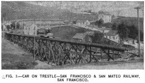
A view of Glen Park in 1893, the earliest known image of our district. The future Diamond and Chenery Street intersection is at the left margin, just before crossing the trestle over Islais Creek. Image from an article about the San Francisco – San Mateo Electric Railway in The Street Railway Journal, 1893.
During the Mexican Period of California (1822-1846), our land became part of the 4,443-acre Rancho San Miguel land grant deeded by Mexican Governor Pío Pico to José de Jesús Noé, who likely continued to maximize grazing opportunities. The Spanish had introduced cattle to the Bay Area in 1776 and by the 1830s, the population of cattle at Mission Dolores had exploded to over 75,000. So, while we may know Portrero Hill as having been named as the portrero (“pasture”) for Mission Dolores, it is likely the massive herd ranged throughout the region, including Glen Canyon and the future Diamond and Chenery Streets.
With a demonstration that cattle thrived in the region, milch ranching (dairy farming) would become the first major industry in the American period. By the late 1850s, milch ranchers George Ulshofer and Henry Wilson had settled the lands closest to our modern village. Ulshofer owned the 10 acres that extended from today’s San Jose Avenue west to Burnside Avenue, and Joost Avenue north to Chenery Street (see Glen Park News, Spring 2016, page 9).
At 109-acres, Wilson’s homestead, platted in 1854, was much larger. It appears it was Wilson who planted a large grove of eucalyptus trees (also known as gum trees), probably as a wind break, that extended west and north from the future Diamond and Chenery intersection. It is this grove that would forever associate our neighborhood with the moniker of Gum Tree (as in the famous Gum Tree Girls who led Glen Park residents in the Freeway Revolt of the 1960s). Yet back in the 1850s, the intersection was still only a bend in the dirt of the Old San Jose Road (the former El Camino Real) just north of the bridge over Islais Creek, and likely a waypoint for thirsty travelers on the long and arduous 9-hour stagecoach ride between downtown San Francisco and San Jose.
By 1862, the stretch of the Old San Jose Road south of 30th Street and around the bend at today’s Natick Street to Castro Street had been renamed for forgotten California pioneer Richard Chenery. A native of Massachusetts, Chenery was a hotel proprietor, side-wheel steamer captain, a member of the California Assembly, and leader of the California contingent in the inauguration parade of President Abraham Lincoln in Washington, D.C. During the Civil War, Chenery served as agent for the U.S. Navy for the Port of San Francisco. He was also president of the Pacific Railroad Homestead Association in 1862 that by 1864 was renamed as the Fairmount District, becoming the first speculative residential development on the West Coast.
In 1872, Ulshofer’s land had become the property of the Mission and Thirtieth Street Extension Homestead Union. Bisected by Berkshire Street (today’s Bosworth) running westward from today’s San Jose Avenue (which at that time was the route of the San Francisco – San Jose Railroad, later the Southern Pacific), the six cross-streets appear to have been named mostly after towns in the state of New York: Croton (Diamond), Fulton (Brompton), Park (Lippard), Hamilton (Hamerton), Clinton (Chilton), and Kingston (Burnside). And while Chenery Street west of Diamond did not yet exist, the small bend in today’s Chenery just beyond Chilton Street is an artifact of Ulshofer’s original property line.
For the remainder of the 19th century, our district was likely populated by more cattle than humans. Save for Wilson’s non-native gum tree grove, the landscape was barren and treeless. But the district was becoming well known for its fertile pastures and rich soil. Taking note and after he had earned a fortune in the 1880s in a dredging investment during the French phase of the Panama Canal, land speculator and capitalist Behrend Joost in 1892 began his development of Sunnyside. Offering 200 lots, it was the largest residential development in San Francisco up to that point. Joost concurrently constructed the San Francisco – San Mateo Railway to transport his new residents to downtown San Francisco. As the city’s first electric railway, it started at the Ferry Building and made its way via Steuart, Harrison, and Bryant to 14th Street, then to Guerrero Street to 30th Street before turning south on Chenery Street. At Diamond Street, the railway turned south again, trundled along the Diamond Street Trestle over Islais Creek, then down what is today San Jose Avenue to the San Mateo County Line. It would later be extended to the cemeteries in Colma.
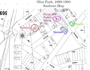
At that time, the future intersection of Diamond and Chenery Streets would have been a cacophony of sound, not only with the rumbling of the electric railway across the trestle, but also from a duck farm on the northwest corner (site of the former Tyger’s Restaurant), a pig farm on the southwest corner, and a tannery on the banks of Islais Creek at today’s BART parking lot. By 1895, Walter Haack had constructed an Eastlake architectural-style commercial building on the site of the pig farm and opened the Gum Tree Saloon. Already a nine-year resident on Chenery near Castro, Haack appeared to recognize the business potential of the Diamond and Chenery intersection. Today it is the site of Glen Park Cleaners and is Glen Park’s oldest commercial structure. Haack made news when the saloon was robbed by a masked gunman in 1897.

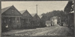
In that same year, Archibald S. Baldwin of the real estate agency Baldwin & Howell would give the name “Glen Park” to our district. Wanting to attract potential buyers to his new home lots along what he called Glen Avenue (today’s Chenery Street from Diamond to Elk Street), he incorporated the Glen Park Company for the express purpose of establishing and maintaining a zoological garden. Glen Park and the Mission Zoo would attract thousands of people every weekend who arrived via the electric railway and disembarked at Diamond and Chenery to enjoy vaudeville shows, boxing and wrestling matches, and death-defying aeronautic displays. Visitors could also promenade among the 140-acre site that stretched from Diamond Street to Glen Canyon to view the aviary, deer and elk, a bear pit, as well as a replica of Morro Castle constructed in honor of the American victory in the Spanish-American War. But when his Glen Park Terrace home lots failed to sell, Baldwin had divested all ownership in the district by 1903. Glen Park and the Mission Zoo became a private pleasuring ground managed by the Crocker Estate.
Two more saloons were constructed, one by August Straub on the southeast corner, and another in 1905 by Anton Dissmeyer which until recently was the site of Tyger’s Restaurant. Several other buildings were also popping up along Chenery Street between Castro and Diamond, including that of today’s Glen Park Hardware Store. But it would be the aftermath of the Great San Francisco Earthquake of 1906 that would lead to a Glen Park population explosion. By 1908, several businesses dotted the area of Diamond and Chenery, as well as south of Diamond and Bosworth. In addition to the saloons, these included two butchers, a confectioner and a bakery, fruits and vegetables, a cigarmaker, a dry goods store (that also housed Glen Park’s first library), varieties, milk dealers, two pharmacies, and a barber. Also in 1908, members of the Glen Park Outdoor Art League would depart from Diamond and Chenery to take the electric railway to the Ferry Building as they made their way to Oakland to lead America’s first march for women’s suffrage.

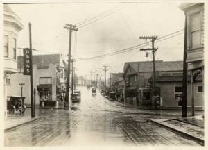
By 1920, Islais Creek had been rerouted underground in the city’s combined water and sewer system. The railway trestle was dismantled and the gulch the creek ran through was filled in, enabling commercial development of the block of Diamond between Chenery and Bosworth Streets. The electric railway, now owned by the United Railroads of San Francisco, continued to run until the early 1940s when it was replaced by diesel buses.
In many ways, the intersection of Diamond and Chenery Streets looks much the same as it did decades ago, adding to the character of the district we call Glen Park Village. Yet, the history it holds is significant, making it unique among most intersections in San Francisco.
…
Evelyn Rose, Director and Founder of the Glen Park Neighborhoods History Project, is documenting the histories of Glen Park and nearby neighborhoods. To learn more about our local histories, visit www.GlenParkHistory.org. The Glen Park Neighborhoods History Project is currently offering intermittent virtual programs during the ongoing health crisis. Join the mailing list: GlenParkHistory@gmail.com. The Glen Park Neighborhoods History Project is fiscally sponsored by Independent Arts & Media, a California non-profit corporation. Evelyn is also the author of the history website, Tramps of San Francisco.
